
Explore the Ocean with Google Maps!
Ann Keibler Oct 11, 2012
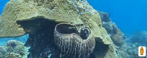
of reefs and virtual tours of popular dive sites available to billions of people who have never experienced the underwater world.
Google hopes to make these dive sites accessible to users to promote interest and conservation of the ocean and the images will be added to an archive for marine scientists to use for studies of these marine environments. From September to December the project will travel down the coast of Australia taking thousands of images that will be continually uploaded new sites to Google Maps. Currently there are six sites available to view on Google Maps, including three sites at the Great Barrier Reef in Australia, two sites in Hawaii, and one of Apo Island in the Philippines.
This is especially exciting for me because I have been lucky enough to dive Apo Island on an Oceanic Ventures trip and it is so cool navigate those sites via the internet! Although these images are amazing, they pale in comparison to the true underwater world of Apo Island. So, although Google cannot quite compare to really experiencing Apo Island, they’re making great strides forward and making dive sites more accessible to non-divers and divers interested in previewing sites in a sustainable way!
You can see what I mean by going here.
